Maps
The value of an antique map is usually determined by the geographical area covered, historical importance, quality of production, size, decorative appeal and rarity.
Maps made during the Golden Age of Exploration (spanning the early 15th to early 17th centuries) are of particular interest to collectors with examples by the 17th century Dutch cartographers Willem Blaeu and his son Joan among the most highly prized.
As well as maps, this category also includes antique atlases, globes, cartographic reference books, travel books, charts and plans.
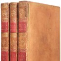
Jane Austen, a compact collection sold at Dominic Winter auction
30 January 2023Small group of the author’s ever-popular works makes a big impression at Gloucestershire saleroom

5 Questions: Clare Wabe of Molly and Harlequin
16 January 2023Clare Wabe of Molly and Harlequin specialises in antique maps and prints with a focus on natural history, though the stock ranges wider.
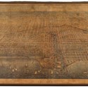
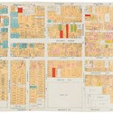
Sizeable Chicago sale led by a huge 7ft wide city map
12 December 2022The creation of James T Palmatary, the engraved and framed birds-eye view or plan of Chicago of 1857 pictured above is almost 7ft wide.
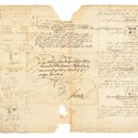
Kepler manuscript’s star value
28 November 2022Calculations on planetary movements rise to the occasion in New York saleroom
Flats full to the brim with books
21 November 2022First part of a collection which covered the walls and cellar of two whole flats is offered at auction
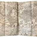
Linschoten’s travels reach £44,000
31 October 2022A Dutch travelogue from the early years of Arctic exploration sold for £44,000 (plus 25% buyer’s premium) at Chiswick Auctions on October 26.
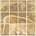
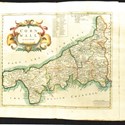
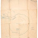
Essex map reaches new height
31 October 2022Estimated at £600-800, a 1777 first in marbled board covers of John Chapman and Peter Andre’s 'Map of the County of Essex from an Actual Survey' was sold for what would appear to be an auction record.
Britannia rules in Surrey saleroom
31 October 2022The big attraction in a job lot estimated at £60-100 that went on to sell for £14,000 in a September 23 sale held by Ewbank’s (25% buyer’s premium) was a copy of Britannia: or, a Chorographical Description…, Dr Edmund Gibson’s 1695, updated and English language version of a well-known earlier work.
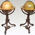
Global interest in Chester
03 October 2022A pair of 19th century globes by the Newton family is on offer from FE Anderson of Welshpool at the Chester Decorative Antiques & Art Fair.
Mapping America in Gloucestershire
19 September 2022Doubling its mid-estimate to sell at £50,000, one of the top lots in a sale of September 7 was Paulo Forlani’s Il Disegno del discoperto della nova Franza…
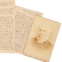
Passenger’s unpublished account of pioneering round-the-world trip surfaces in a saleroom
22 August 2022In the years 1881-82, the Rev William Essery was for many months a passenger on the SS Ceylon.
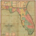
Rare map of Florida from 1829 sold at Doyle
18 July 2022The Map of Florida shown here was issued in 1829 to encourage settlement following its still recent acquisition from Spain.
Neptune buyer splashes out
04 July 2022Set of charts, plans and views was published by the Admiralty for Royal Navy use
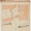
Shackleton maps out his routes
20 June 2022Dramatic rescue of 1916 was recorded visually by the polar explorer two years later
San Frantastic views sold locally
06 June 2022Maps and views of San Francisco were among the principal attractions of an April 21 sale held by local auction house PBA Galleries (25/20% buyer’s premium) to disperse the first portion of the Charles Fraccia Collection.
Map of Antigua sails to over 20-times estimate
23 May 2022Estimated at just $200-300, this folding map of the island of Antigua proved rather more expensive than expected.
London Map Fair: Discoveries new and old
16 May 2022Dealer Tim Bryars previews this year’s London Map Fair with an eye on current collecting trends
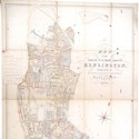
Kensington mapped out and Le Carré in a designer jacket
11 April 2022Bid to £2800 in a recent Norfolk sale was a detailed and now rare Map of the Parish of St Mary Abbotts, Kensington… dating from 1879.
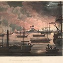
Burmese blaze and golden gains
07 March 2022Nineteenth century aquatint and map provide global perspective in Gloucestershire saleroom
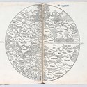
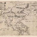
Curious but costly world view
17 January 2022In Rodney Shirley’s monumental study of 'The Mapping of the World… 1472-1700', the very first entry is a simple, circular woodcut known as a ‘T-O’ map, one in which the continents of Asia, Europe and Africa are very simply shown as named segments.

- Wilson 55
- Coins & Banknotes
- 25 Apr 2024 - 14:00 PM
- J.S. Fine Art Auctioneers
- Selected Antiques & Country House Interiors
- 26 Apr 2024 - 10:00 AM
- The Auction Centre
- Antiques & Fine Art
- 26 Apr 2024 - 10:00 AM
- Wotton Auction Rooms
- Garden & Interiors
- 27 Apr 2024 - 09:00 AM
- Excalibur Auctions
- Posters, Memorabilia & Vinyl
- 27 Apr 2024 - 10:00 AM
- Mallams Abingdon
- Home & Interiors
- 29 Apr 2024 - 10:00 AM

Categories
-
- Arms, Armour & Militaria
- Bank notes
- Books & Periodicals
- Cameras & Camera Equipment
- Classic Cars, Motorcycles & Automobilia
- Coins
- Collectables
- Entertainment Memorabilia
- Kitchenalia
- Maps
- Models, Toys, Dolls & Games
- Musical Instruments & Memorabilia
- Scientific Instruments
- Sporting Memorabilia & Equipment
- Stamps
- Taxidermy & Natural History
- Tools
- Wines & Spirits
- Writing Instruments
News
-
- Art finance
- Auctions
- Brexit
- Buyer's and seller's premiums
- Coronavirus
- Delivery and Shipping
- Education and Training
- Endangered Species
- Events and conferences
- Industry data
- Insurance
- Internet
- Law, crime and regulation
- Museum acquisitions
- Museum deaccessioning
- Obituaries
- Premises and Property
- Private Sales
- Recruitment
- Restoration
- TV shows
-
- 1818 Auctioneers
- Adam Partridge
- Adam's
- Addisons
- Ader
- Aguttes
- Alastair Gibson Auctions
- Alcala Subastas
- Aldridges
- Amersham Auction Rooms
- Anderson & Garland
- Andrew Smith & Son
- Anthemion
- AntikBar
- Antony Cribb
- Artcurial
- Arthur Johnson & Sons
- Aston's
- Auction Team Breker
- Auctionata
- Auctioneum
- Babuino
- Bainbridge Adam Partridge
- Baldwin's
- Bamfords
- Barbara Kirk
- Barbers
- Batemans
- BBR Auctions
- Bearnes Hampton & Littlewood
- Beaussant Lefèvre
- Bellmans
- Bentley’s
- Biddle & Webb
- Bigwood
- Bishop & Miller
- Bleasdales
- Bloomsbury Auctions
- Boldon Auction Galleries
- Bonhams
- Bonhams Skinner
- Bosleys
- Bourne End Auction Rooms
- Brettells
- Brighton General Auctions
- Brightwells
- Bristol Auction Rooms
- Brown & Co
- Bruun Rasmussen
- Burstow & Hewett
- Byrnes
- C&T
- Cambi Casa d'Aste
- Canterbury Auction Galleries
- Capes Dunn
- Catherine Southon
- Cato Crane
- Chalkwell
- Charles Miller
- Charles Ross Auctioneers
- Charterhouse
- Cheffins
- Chilcotts
- Chippenham Auction Rooms
- Chiswick Auctions
- Chorley's
- Christie's
- Clark & Simpson
- Clars Auction Gallery
- Clevedon Salerooms
- Comic Book Auctions
- Cotswold Auction Company
- Cottees
- Cowans
- Criterion
- Crow’s Auctions Gallery
- Curated Auctions
- Cuttlestones
- Czerny
- David Duggleby
- Dawsons
- Denhams
- Dominic Winter
- Dore & Rees
- Dorotheum
- Doyle New York
- Dreweatts
- Duke's
- Durrants
- Eastbourne Auctions
- Eldreds
- Elmwood’s
- Elstob Auctioneers
- Ewbank's
- Featonby's
- Fellows
- Fieldings
- Fine Art Auction Group
- Fine Art Bourse
- Flints Auctioneers
- Fonsie Mealy
- Forum Auctions
- Frank Marshall
- Freeman's
- Freeman's Hindman
- Gardiner Houlgate
- Gary Don
- George Kidner
- Gerrards Auction Rooms
- Gildings
- Golding Young & Mawer
- Gorringes
- Graham Budd
- Grand Auctions
- Great Western Auctions
- Greenslade Taylor Hunt
- Gros & Delettrez
- H&H Classics
- Halls Fine Art
- Hampstead Auctions
- Hannam’s
- Hansons
- Harper Field
- Hartleys
- Henry Adams
- Henry Aldridge & Son
- Heritage Auctions
- Hermann Historica
- High Road Auctions
- Hindman
- Holloways
- Holt's
- Hôtel Drouot
- Hotlotz
- Humbert & Ellis
- Hutchinson Scott
- Jacobs & Hunt
- John Nicholson
- John Pye Auctions
- Jones & Jacob
- JS Fine Art
- Jubilee Auction Rooms
- Juliens
- Kerry Taylor
- KettererKunst
- Keys
- Kidson-Trigg
- Kinghams
- Kings Russell
- Knights Auctions
- Knowle Auction Rooms
- Koller
- Lacy Scott & Knight
- Laidlaw
- Lawrences of Bletchingley
- Lawrences of Crewkerne
- Lay’s Auctioneers
- Lempertz
- Leonard Joel
- Lindsay Burns
- Littleton
- Lockdales
- Locke & England
- London Auctions
- Lots Road Auctions
- Louis Taylor
- Lyon & Turnbull
- MacDougall's
- Mallams
- Mander
- Marlows of Stafford
- Martel Maides
- Maxwells
- McTear's
- Mellors & Kirk
- Michael Bowman
- Millon
- Minster Auctions
- Mitchells
- Moore Allen & Innocent
- Morphets
- Morton & Eden
- Mossgreen
- Mulberry Bank Auctions
- Mullock's
- Nagel
- Nesbits
- Netherhampton Salerooms
- Nicholas Mellors
- Nigel Ward
- Noble Investments
- Noonans
- Olympia Auctions
- Omega Auctions
- Onslows
- Osenat
- Paddle8
- Parker Fine Art Auctions
- Paul Beighton Saleroom
- PBA Galleries
- Peter Francis
- Philip Serrell
- Phillips
- Piasa
- Pierre Bergé & Associes
- Piers Motley
- Plymouth Auction Rooms
- Potter & Potter
- Potteries Auctions
- Rago Auctions
- Railtons
- Ramsay Cornish
- Reeman Dansie
- Rendells
- Richard Edmonds Auctions
- Richard Winterton
- Ritchies
- RM Sotheby’s
- Rogers Jones
- Roma Numismatics
- Roseberys
- Ross’s of Belfast
- Rowley's
- Rushbrooks
- Ryedale
- Semley
- Sheffield Auction Gallery
- Sheppard’s
- Silverwoods
- Sloane Street Auctions
- Sotheby's
- Sovereign Rarities
- Special Auction Services
- Spicers
- Spink
- St Jamess Auctions
- Staceys
- Stanley Gibbons Group
- Sterling Vault Auctioneers
- StockholmsAuktionsverk
- Stride & Son
- Summers Place Auctions
- Swan Fine Art Auctioneers
- Swann
- Sworders
- Tajan
- Tamlyns
- Tayler and Fletcher
- Taylor's Auctions
- Tennants
- The Pedestal
- Thimbleby & Shorland
- Thomas Del Mar
- Thomas N Miller
- Thomas R Callan
- Thomas Watson
- Thomaston Place
- Thomson Roddick & Medcalf
- Thomson Roddick Scottish Auctions
- Timeline
- Toovey's
- Trevanion
- Truro Auction Centre
- TW Gaze
- Unique Auctions
- Vectis
- Veritas
- W&H Peacock
- Wallis and Wallis
- Warren & Wignall
- Watches of Knightsbridge
- Wellers
- Wessex Auction Rooms
- Whitton & Laing
- Whittons
- Whytes
- Wilkes & Curtis
- Wilkinson's Auctioneers
- William George & Co
- Wilson55
- Woolley & Wallis
- Wotton Auction Rooms
- Wright Marshall
-
- 1stdibs
- Advertising Standards Authority
- Antiquarian Booksellers Association
- Antique Young Guns
- Antiquities Dealers’ Association
- Art Business Conference
- Art Fund
- Art Loss Register
- Art Recovery International
- Art UK
- Arts Council England
- Assay Office
- Auction Technology Group
- BADA
- BAMF
- CADA
- CINOA
- Company of Arts Scholars
- DACS
- DEFRA
- DMG
- EBay
- Hiscox
- LAPADA
- Lot-tissimo
- National Trust
- NAVA
- Provincial Booksellers Fairs Association
- RICS
- Society of London Art Dealers
- SOFAA
- the saleroom
- Triple-A Auctioneers
-
- Adams Antiques Fairs
- Affordable Art Fair
- Alexandra Palace fair
- Antiques Centres
- Antiques Dealers Fair Limited
- Ardingly Fair
- Armchair Art Fair
- Art & Antiques for Everyone Fair
- Art Antiques London
- Art, Antiques & Interiors Expo
- Arthur Swallow Fairs
- Bath Decorative Antiques Fair
- Battersea Decorative Fair
- Bermondsey Market
- Book Fairs
- BRAFA
- British Art Fair
- Brussels Fairs
- CADA Fair
- Car Boot Fairs
- Clarion Events
- Continuity Fairs
- Cooper Events
- Ephemera fairs
- Fine Art Asia
- Fine Arts Paris
- Firsts
- Florida Fairs
- French Fairs
- Frieze
- Frieze Masters
- Galloway Antiques Fairs
- Harrogate Fairs
- Hatton Garden
- Haughton Fairs
- Hong Kong Fairs
- IACF
- Jaguar Fairs
- LAPADA Fair
- Lincolnshire Antiques and Home Show
- London Original Print Fair
- Masterpiece
- Miami Fairs
- Midcentury Modern
- Modern British Art Fair
- NEC Birmingham
- New York Fairs
- Newark Fair
- Newbury Antiques and Collectors Fair
- Olympia Fair
- PAD London
- Palm Beach Fairs
- Paris Biennale
- Paris Fairs
- Paris Parcours
- Paris Tableau
- Penman Fairs
- Philadelphia Fairs
- Photography fairs
- Regional Fairs
- Salon du Dessin
- Sandown Park Racecourse Fair
- Showground Fairs
- Swinderby Fair
- TEFAF
- The Open Art Fair
- The Treasure House Fair
- Winter Antiques Show
- Works on Paper Fair
-
- Alfred Taubman
- Bendor Grosvenor
- Bill Ruprecht
- Charles Hanson
- Charlie Ross
- Cornelius Gurlitt
- David Lester
- Ed Dolman
- Eric Knowles
- François Pinault
- Ingrid Nilson
- Lennox Cato
- Lord Ashcroft
- Marco Forgione
- Mark Law
- Sheikh Saud Bin Mohammed Al-Thani
- Simon de Pury
- Sue Ede
- Tad Smith
- Tim Goodman
- Victoria Borwick
-
- Abbott and Holder
- Agnews
- Alastair Dickenson
- Andrew Sim
- Blairman
- Carter Marsh
- Colnaghi
- Daniel Katz
- Dickinson
- Fabrizio Moretti
- Ian Towning
- Johnny Van Haeften
- London Silver Vaults
- Mallett
- Mark Weiss
- Partridge Fine Art
- Petworth Antiques Dealers
- Philip Mould
- Pimlico Road Dealers
- Richard Green
- Robert Young
- Roger Keverne
- Rupert Maas
- SJ Phillips
- Wartski
-
- A Lawyer Writes
- Around the Auction Houses
- Art Market
- Auction Reports
- Bid Barometer
- Books and Works on Paper
- Dealers' Diary
- Fairs, Markets, Shops and Centres
- Features
- Front Page and News
- International (print edition)
- Interviews
- Letters to the Editor
- News in Brief
- Obituaries (print edition)
- Opinion
- Pick of the Week
- Precious Metals Prices
- Previews
- Soapbox
- Special Reports
- Then & Now