Maps
The value of an antique map is usually determined by the geographical area covered, historical importance, quality of production, size, decorative appeal and rarity.
Maps made during the Golden Age of Exploration (spanning the early 15th to early 17th centuries) are of particular interest to collectors with examples by the 17th century Dutch cartographers Willem Blaeu and his son Joan among the most highly prized.
As well as maps, this category also includes antique atlases, globes, cartographic reference books, travel books, charts and plans.
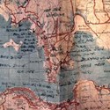
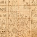
Hong Kong could be key surprise result for military maps
16 March 2020Four military maps encompassing Siam (Thailand), Hong Kong, Iraq, Kuwait and Saudi Arabia took an unexpected £3700 at the Peter Wilson (22% buyer’s premium) Arms, Militaria, Medals & Firearms auction earlier this year.
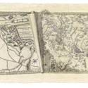
Siege of Maastricht map among highlights at TEFAF Maastricht
04 March 2020The city of Maastricht itself will take pride of place on Daniel Crouch Rare Books’ stand at TEFAF, set to open tomorrow.
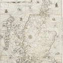
Pick of the week: 'Oldest accurate map of coastal Scotland' becomes auction trailblazer
24 February 2020'La Navigation du Roy d’Ecosse' by the French cartographer Nicolas de Nicolay (1517-83) is said to be the oldest accurate map of coastal Scotland.
Maps pro and amateur draw attention at Dominic Winter
10 February 2020As ever, the most recent sale held by Dominic Winter (20% buyer’s premium) contained a great many maps and atlases and shown below is one of the highlights.
The web shop window: Rare English edition of Petrus Plancius' map of the Spice Islands
06 January 2020Thousands of items are available to buy from dealers online. Here we pick out one that caught our eye this week.
Colonial North America discoveries put Scottish saleroom on the map
16 December 2019Two key early maps of colonial North America were offered for sale at Ramsay Cornish in Edinburgh on December 7.
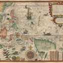
Arctic sailing journey complete with sea monsters
25 November 2019Bid to £32,000 in a Gloucestershire auction was a 1599, first Latin edition of the Dutch traveller and explorer, Jan Huygen van Linschoten’s Navigatio ac itinerarium…
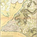
New York and Houston outlined
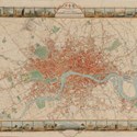
25 November 2019A selection of maps of US cities from recent auctions stateside.
Maps make their mark with prices far beyond estimates
04 November 2019Focusing on south-east Asia, a 90-lot map section in an Essex sale comprised the extraordinarily successful first portion of a collection of maps and charts assembled by Christopher Beresford-Jones.
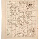
American map discoveries in Scotland
28 October 2019Two early maps of colonial north America come for sale at Ramsay Cornish in Edinburgh on December 7. They were discovered at the Edinburgh home of the late Dr Ann Carswell, an American born in Washington and educated at Cornell and Harvard.
‘Father of Parole’ outlines his views on penal reform
14 October 2019One exceptional and very successful lot in a recent Yorkshire sale focused on penal reforms on the far side of the world.
Soaked and shabby world map revealed to be by John Speed makes more than five times high estimate
09 October 2019A 17th century map by John Speed (1552-1629) sold at a Woolley & Wallis auction last week after being dumped in a wet, broken frame at a London charity shop.
‘Mother of all Philippine maps’ sells in Essex auction
30 September 2019The first tranche of a private collection of predominantly Far Eastern maps and charts sold for more than £500,000 at Reeman Dansie and included a house record.
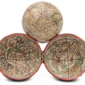
Buyer has no fear of the unknown as pocket globe leads Exeter auction
16 September 2019A pocket globe with some areas still a mystery leads a maritime auction at Exeter saleroom Bearnes Hampton & Littlewood.
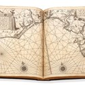
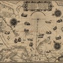
Blaeu blows to a record result
26 August 2019This double-page engraved chart is from an early-17th century pilot book which is another of the highlights from the Mopelia Collection of atlases and travel books offered in London.
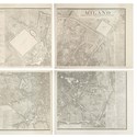
Map of Milan offered at Il Ponte
26 August 2019This map of Milan will feature in the sale of books and manuscripts to be held in the city by Il Ponte on September 24.
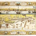
Pick of the week: 18th century dockyard plans detailing the Royal Navy war machine attract wave of bids
19 August 2019A complete set of plans showing what was once the world’s largest industrial complex and the British state’s single biggest investment has sold in Cornwall. Thomas Milton’s plans of the Royal Dockyards sold to an online buyer for £10,000 (plus 18% buyer’s premium) at David Lay's latest sale in Penzance.
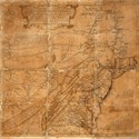
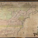
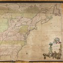
Pick of the week: Early draft of colonial American map impresses at New York auction
17 June 2019A pre-press version of a key map of colonial America emerged for sale at Swann Auction Galleries in New York on June 6. Carrying an estimate of $30,000-50,000, it sold at $100,000/£76,900 (plus 25% buyer’s premium) – a sum that reflected its extraordinary provenance.
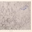
Lunar map to give you a Buzz at London Map Fair
03 June 2019Over in Kensington Gore’s Royal Geographical Society, The London Map Fair includes an astronomical highlight to mark the 50th anniversary of the first moonwalk. The map, signed and inscribed by Buzz Aldrin, shows the lunar landing site, and is offered by The Map House for £7500.
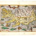
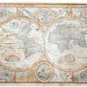
Ortelius atlas with sea monsters off Iceland is popular feature of auction with global outlook
27 May 2019Successfully bid to £80,000 among cartographic lots offered in London was a fine coloured copy of Ortelius’ Theatrum… of 1592.

- Moore Allen & Innocent
- Furniture & Interiors
- 24 Apr 2024 - 10:00 AM
- Anderson & Garland
- Pictures
- 25 Apr 2024 - 10:00 AM
- Lay's Auctioneers
- Watches
- 25 Apr 2024 - 10:00 AM
- Wilson 55
- Coins & Banknotes
- 25 Apr 2024 - 14:00 PM
- J.S. Fine Art Auctioneers
- Selected Antiques & Country House Interiors
- 26 Apr 2024 - 10:00 AM
- The Auction Centre
- Antiques & Fine Art
- 26 Apr 2024 - 10:00 AM

Categories
-
- Arms, Armour & Militaria
- Bank notes
- Books & Periodicals
- Cameras & Camera Equipment
- Classic Cars, Motorcycles & Automobilia
- Coins
- Collectables
- Entertainment Memorabilia
- Kitchenalia
- Maps
- Models, Toys, Dolls & Games
- Musical Instruments & Memorabilia
- Scientific Instruments
- Sporting Memorabilia & Equipment
- Stamps
- Taxidermy & Natural History
- Tools
- Wines & Spirits
- Writing Instruments
News
-
- Art finance
- Auctions
- Brexit
- Buyer's and seller's premiums
- Coronavirus
- Delivery and Shipping
- Education and Training
- Endangered Species
- Events and conferences
- Industry data
- Insurance
- Internet
- Law, crime and regulation
- Museum acquisitions
- Museum deaccessioning
- Obituaries
- Premises and Property
- Private Sales
- Recruitment
- Restoration
- TV shows
-
- 1818 Auctioneers
- Adam Partridge
- Adam's
- Addisons
- Ader
- Aguttes
- Alastair Gibson Auctions
- Alcala Subastas
- Aldridges
- Amersham Auction Rooms
- Anderson & Garland
- Andrew Smith & Son
- Anthemion
- AntikBar
- Antony Cribb
- Artcurial
- Arthur Johnson & Sons
- Aston's
- Auction Team Breker
- Auctionata
- Auctioneum
- Babuino
- Bainbridge Adam Partridge
- Baldwin's
- Bamfords
- Barbara Kirk
- Barbers
- Batemans
- BBR Auctions
- Bearnes Hampton & Littlewood
- Beaussant Lefèvre
- Bellmans
- Bentley’s
- Biddle & Webb
- Bigwood
- Bishop & Miller
- Bleasdales
- Bloomsbury Auctions
- Boldon Auction Galleries
- Bonhams
- Bonhams Skinner
- Bosleys
- Bourne End Auction Rooms
- Brettells
- Brighton General Auctions
- Brightwells
- Bristol Auction Rooms
- Brown & Co
- Bruun Rasmussen
- Burstow & Hewett
- Byrnes
- C&T
- Cambi Casa d'Aste
- Canterbury Auction Galleries
- Capes Dunn
- Catherine Southon
- Cato Crane
- Chalkwell
- Charles Miller
- Charles Ross Auctioneers
- Charterhouse
- Cheffins
- Chilcotts
- Chippenham Auction Rooms
- Chiswick Auctions
- Chorley's
- Christie's
- Clark & Simpson
- Clars Auction Gallery
- Clevedon Salerooms
- Comic Book Auctions
- Cotswold Auction Company
- Cottees
- Cowans
- Criterion
- Crow’s Auctions Gallery
- Curated Auctions
- Cuttlestones
- Czerny
- David Duggleby
- Dawsons
- Denhams
- Dominic Winter
- Dore & Rees
- Dorotheum
- Doyle New York
- Dreweatts
- Duke's
- Durrants
- Eastbourne Auctions
- Eldreds
- Elmwood’s
- Elstob Auctioneers
- Ewbank's
- Featonby's
- Fellows
- Fieldings
- Fine Art Auction Group
- Fine Art Bourse
- Flints Auctioneers
- Fonsie Mealy
- Forum Auctions
- Frank Marshall
- Freeman's
- Freeman's Hindman
- Gardiner Houlgate
- Gary Don
- George Kidner
- Gerrards Auction Rooms
- Gildings
- Golding Young & Mawer
- Gorringes
- Graham Budd
- Grand Auctions
- Great Western Auctions
- Greenslade Taylor Hunt
- Gros & Delettrez
- H&H Classics
- Halls Fine Art
- Hampstead Auctions
- Hannam’s
- Hansons
- Harper Field
- Hartleys
- Henry Adams
- Henry Aldridge & Son
- Heritage Auctions
- Hermann Historica
- High Road Auctions
- Hindman
- Holloways
- Holt's
- Hôtel Drouot
- Hotlotz
- Humbert & Ellis
- Hutchinson Scott
- Jacobs & Hunt
- John Nicholson
- John Pye Auctions
- Jones & Jacob
- JS Fine Art
- Jubilee Auction Rooms
- Juliens
- Kerry Taylor
- KettererKunst
- Keys
- Kidson-Trigg
- Kinghams
- Kings Russell
- Knights Auctions
- Knowle Auction Rooms
- Koller
- Lacy Scott & Knight
- Laidlaw
- Lawrences of Bletchingley
- Lawrences of Crewkerne
- Lay’s Auctioneers
- Lempertz
- Leonard Joel
- Lindsay Burns
- Littleton
- Lockdales
- Locke & England
- London Auctions
- Lots Road Auctions
- Louis Taylor
- Lyon & Turnbull
- MacDougall's
- Mallams
- Mander
- Marlows of Stafford
- Martel Maides
- Maxwells
- McTear's
- Mellors & Kirk
- Michael Bowman
- Millon
- Minster Auctions
- Mitchells
- Moore Allen & Innocent
- Morphets
- Morton & Eden
- Mossgreen
- Mulberry Bank Auctions
- Mullock's
- Nagel
- Nesbits
- Netherhampton Salerooms
- Nicholas Mellors
- Nigel Ward
- Noble Investments
- Noonans
- Olympia Auctions
- Omega Auctions
- Onslows
- Osenat
- Paddle8
- Parker Fine Art Auctions
- Paul Beighton Saleroom
- PBA Galleries
- Peter Francis
- Philip Serrell
- Phillips
- Piasa
- Pierre Bergé & Associes
- Piers Motley
- Plymouth Auction Rooms
- Potter & Potter
- Potteries Auctions
- Rago Auctions
- Railtons
- Ramsay Cornish
- Reeman Dansie
- Rendells
- Richard Edmonds Auctions
- Richard Winterton
- Ritchies
- RM Sotheby’s
- Rogers Jones
- Roma Numismatics
- Roseberys
- Ross’s of Belfast
- Rowley's
- Rushbrooks
- Ryedale
- Semley
- Sheffield Auction Gallery
- Sheppard’s
- Silverwoods
- Sloane Street Auctions
- Sotheby's
- Sovereign Rarities
- Special Auction Services
- Spicers
- Spink
- St Jamess Auctions
- Staceys
- Stanley Gibbons Group
- Sterling Vault Auctioneers
- StockholmsAuktionsverk
- Stride & Son
- Summers Place Auctions
- Swan Fine Art Auctioneers
- Swann
- Sworders
- Tajan
- Tamlyns
- Tayler and Fletcher
- Taylor's Auctions
- Tennants
- The Pedestal
- Thimbleby & Shorland
- Thomas Del Mar
- Thomas N Miller
- Thomas R Callan
- Thomas Watson
- Thomaston Place
- Thomson Roddick & Medcalf
- Thomson Roddick Scottish Auctions
- Timeline
- Toovey's
- Trevanion
- Truro Auction Centre
- TW Gaze
- Unique Auctions
- Vectis
- Veritas
- W&H Peacock
- Wallis and Wallis
- Warren & Wignall
- Watches of Knightsbridge
- Wellers
- Wessex Auction Rooms
- Whitton & Laing
- Whittons
- Whytes
- Wilkes & Curtis
- Wilkinson's Auctioneers
- William George & Co
- Wilson55
- Woolley & Wallis
- Wotton Auction Rooms
- Wright Marshall
-
- 1stdibs
- Advertising Standards Authority
- Antiquarian Booksellers Association
- Antique Young Guns
- Antiquities Dealers’ Association
- Art Business Conference
- Art Fund
- Art Loss Register
- Art Recovery International
- Art UK
- Arts Council England
- Assay Office
- Auction Technology Group
- BADA
- BAMF
- CADA
- CINOA
- Company of Arts Scholars
- DACS
- DEFRA
- DMG
- EBay
- Hiscox
- LAPADA
- Lot-tissimo
- National Trust
- NAVA
- Provincial Booksellers Fairs Association
- RICS
- Society of London Art Dealers
- SOFAA
- the saleroom
- Triple-A Auctioneers
-
- Adams Antiques Fairs
- Affordable Art Fair
- Alexandra Palace fair
- Antiques Centres
- Antiques Dealers Fair Limited
- Ardingly Fair
- Armchair Art Fair
- Art & Antiques for Everyone Fair
- Art Antiques London
- Art, Antiques & Interiors Expo
- Arthur Swallow Fairs
- Bath Decorative Antiques Fair
- Battersea Decorative Fair
- Bermondsey Market
- Book Fairs
- BRAFA
- British Art Fair
- Brussels Fairs
- CADA Fair
- Car Boot Fairs
- Clarion Events
- Continuity Fairs
- Cooper Events
- Ephemera fairs
- Fine Art Asia
- Fine Arts Paris
- Firsts
- Florida Fairs
- French Fairs
- Frieze
- Frieze Masters
- Galloway Antiques Fairs
- Harrogate Fairs
- Hatton Garden
- Haughton Fairs
- Hong Kong Fairs
- IACF
- Jaguar Fairs
- LAPADA Fair
- Lincolnshire Antiques and Home Show
- London Original Print Fair
- Masterpiece
- Miami Fairs
- Midcentury Modern
- Modern British Art Fair
- NEC Birmingham
- New York Fairs
- Newark Fair
- Newbury Antiques and Collectors Fair
- Olympia Fair
- PAD London
- Palm Beach Fairs
- Paris Biennale
- Paris Fairs
- Paris Parcours
- Paris Tableau
- Penman Fairs
- Philadelphia Fairs
- Photography fairs
- Regional Fairs
- Salon du Dessin
- Sandown Park Racecourse Fair
- Showground Fairs
- Swinderby Fair
- TEFAF
- The Open Art Fair
- The Treasure House Fair
- Winter Antiques Show
- Works on Paper Fair
-
- Alfred Taubman
- Bendor Grosvenor
- Bill Ruprecht
- Charles Hanson
- Charlie Ross
- Cornelius Gurlitt
- David Lester
- Ed Dolman
- Eric Knowles
- François Pinault
- Ingrid Nilson
- Lennox Cato
- Lord Ashcroft
- Marco Forgione
- Mark Law
- Sheikh Saud Bin Mohammed Al-Thani
- Simon de Pury
- Sue Ede
- Tad Smith
- Tim Goodman
- Victoria Borwick
-
- Abbott and Holder
- Agnews
- Alastair Dickenson
- Andrew Sim
- Blairman
- Carter Marsh
- Colnaghi
- Daniel Katz
- Dickinson
- Fabrizio Moretti
- Ian Towning
- Johnny Van Haeften
- London Silver Vaults
- Mallett
- Mark Weiss
- Partridge Fine Art
- Petworth Antiques Dealers
- Philip Mould
- Pimlico Road Dealers
- Richard Green
- Robert Young
- Roger Keverne
- Rupert Maas
- SJ Phillips
- Wartski
-
- A Lawyer Writes
- Around the Auction Houses
- Art Market
- Auction Reports
- Bid Barometer
- Books and Works on Paper
- Dealers' Diary
- Fairs, Markets, Shops and Centres
- Features
- Front Page and News
- International (print edition)
- Interviews
- Letters to the Editor
- News in Brief
- Obituaries (print edition)
- Opinion
- Pick of the Week
- Precious Metals Prices
- Previews
- Soapbox
- Special Reports
- Then & Now