Maps
The value of an antique map is usually determined by the geographical area covered, historical importance, quality of production, size, decorative appeal and rarity.
Maps made during the Golden Age of Exploration (spanning the early 15th to early 17th centuries) are of particular interest to collectors with examples by the 17th century Dutch cartographers Willem Blaeu and his son Joan among the most highly prized.
As well as maps, this category also includes antique atlases, globes, cartographic reference books, travel books, charts and plans.
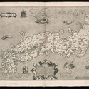
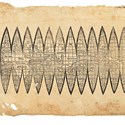
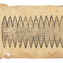
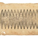
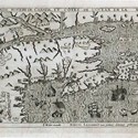
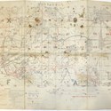
Unprecedented collection of maps of Japan offered by Daniel Crouch Rare Books in Tokyo
21 March 2018Daniel Crouch Rare Books offers what is dubbed the largest collection of maps of Japan ever to come on the open market at this week’s Tokyo Book Fair.
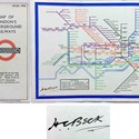
Call for help to find London underground map stolen from auction house
19 March 2018Transport Auctions of London is calling for the trade to look out for a stolen London Underground map.
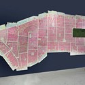
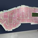
Map of the very Big Apple sold at $250,000
12 February 2018Daniel Crouch Rare Books sold this huge 25ft (7.6m) wide ‘Atlas of the City of New York – Borough of Manhattan’ map at the Winter Antiques Show last month.
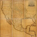
The US breaks out to the west
29 January 2018The American West was the theme of a 43-lot, single-owner collection offered as part of the January 17 sale held by Sotheby’s New York.
Christie’s pulls Waldseemüller gores ‘pending further research’ over date
18 December 2017A ‘rediscovered’ fifth copy of Martin Waldseemüller’s globe gores from c.1507 was withdrawn from sale last week after a group of academics and dealers in the US expressed doubts over its authenticity.
Christie’s withdraws ‘first map’ of America after experts suggest it may be fake
12 December 2017At the eleventh hour, Christie’s has taken the decision to withdraw the headline lot from the December 13 Books and Manuscripts sale in London after serious doubts were expressed over its authenticity.
Dealer Daniel Crouch brings New York maps home to the Winter Antiques Show
06 December 2017New York, London and Paris will be put on the map at the stand of Daniel Crouch Rare Books in the new year at the Winter Antiques Show in Park Avenue Armory in New York.
The first map to name America – rediscovered copy of Martin Waldseemüller’s globe gores emerges at Christie’s auction
09 November 2017A previously unrecorded set of globe gores that name America for the first time will be offered at Christie's in London on December 9.
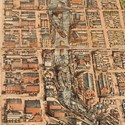
Was it a cow or a card game that set Chicago ablaze?
21 September 2017How the 1871 Chicago fire started remains a matter of conjecture, though a lantern knocked over by a Mrs O’Leary’s cow, or perhaps by a group of men who were gambling in a barn are among the favourite theories.
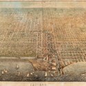
Chicago collector wins $200,000 bidding battle for 1857 map of the “Windy City” at Leslie Hindman auction
18 September 2017One of only four known copies of a ‘pre-fire’ Chicago map by cartographer J.T. Palmatary drew intense competition at Leslie Hindman Auctioneers’ latest sale, selling at over six-times estimate.
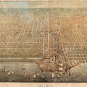
Rare pre-fire map of Chicago heads to local auction complete with view of red light district
05 September 2017One of only four known copies a 19th century map of Chicago goes under the hammer at a local auction house next week.
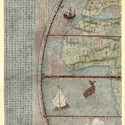
Explore the world’s outer reaches
04 September 2017Just the two outer panels of what had once been a six-part world map remained in a cartographic lot offered at Christie’s (25/20/12% buyer’s premium).
Map marks early view of Canada
17 July 2017Marc Lescarbot’s Nova Francia… of 1609 is an account of French settlements in North America and what we now think of as Nova Scotia and Canada. It predates the more famous first accounts of Champlain’s voyages and discoveries by three years.
London Map Fair attracts international and domestic exhibitors
30 May 2017The annual London Map Fair unites the classic and the quirky of cartographic history under one roof as a host of international dealers show up for what organisers boast is the world’s largest event of its kind.
West End dealer offers rare engraving of one of England’s worst naval defeats at London Map Fair
18 May 2017A map showing one of the few occasions since 1066 that a part of England has been occupied by foreign forces will be offered at the London Map Fair next month.
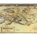
‘Most valuable Disneyland artefact ever offered at auction’ heads to Californian saleroom
15 May 2017More than 1000 Disneyland props and souvenirs are heading to auction in California next month.
Mapping the 20th century
02 May 2017Interest in 20th century maps is growing rapidly among dealers, collectors and curators. And some are rarer than you might think, writes Tim Bryars.
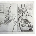
Rare Blaeu maps of Asia and Australia emerge at Sotheby’s upcoming auction
24 April 2017Willem Janszoon Blaeu (c.1570-1638) of Amsterdam and his son, Joan (1596-1673), were the leading figures in the atlas and map publishing world in an age when that Dutch city was the centre of European cartographic achievement.
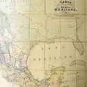
BOOKS AND WORKS ON PAPER: Mapping the American Southwest
01 April 2017Shropshire auctioneer sells ‘cartographic cornerstone’ of Tex-Mex history at surprise £16,500...
Who lost the continents of Lemuria and Mu?
01 April 2017'So Geographers in Afric maps With Savage-Pictures fiill their Gaps; And o’er uninhabitable Downs Place Elephants for want of Towns'.

- Hutchinson Scott
- Fine Interiors
- 16 Apr 2024 - 10:00 AM
- Tennants
- Natural History & Taxidermy
- 17 Apr 2024 - 09:30 AM
- Bamfords
- Antiques, Interiors, Estates & Collectables
- 17 Apr 2024 - 10:00 AM
- McTear's
- Antiques & Interiors
- 18 Apr 2024 - 09:30 AM
- Mendip Auction Rooms
- Sporting, Wines & Spirits
- 18 Apr 2024 - 10:00 AM
- Tennants
- Antiques & Interiors
- 19 Apr 2024 - 09:30 AM

Categories
-
- Arms, Armour & Militaria
- Bank notes
- Books & Periodicals
- Cameras & Camera Equipment
- Classic Cars, Motorcycles & Automobilia
- Coins
- Collectables
- Entertainment Memorabilia
- Kitchenalia
- Maps
- Models, Toys, Dolls & Games
- Musical Instruments & Memorabilia
- Scientific Instruments
- Sporting Memorabilia & Equipment
- Stamps
- Taxidermy & Natural History
- Tools
- Wines & Spirits
- Writing Instruments
News
-
- Art finance
- Auctions
- Brexit
- Buyer's and seller's premiums
- Coronavirus
- Delivery and Shipping
- Education and Training
- Endangered Species
- Events and conferences
- Industry data
- Insurance
- Internet
- Law, crime and regulation
- Museum acquisitions
- Museum deaccessioning
- Obituaries
- Premises and Property
- Private Sales
- Recruitment
- Restoration
- TV shows
-
- 1818 Auctioneers
- Adam Partridge
- Adam's
- Addisons
- Ader
- Aguttes
- Alastair Gibson Auctions
- Alcala Subastas
- Aldridges
- Amersham Auction Rooms
- Anderson & Garland
- Andrew Smith & Son
- Anthemion
- AntikBar
- Antony Cribb
- Artcurial
- Arthur Johnson & Sons
- Aston's
- Auction Team Breker
- Auctionata
- Auctioneum
- Babuino
- Bainbridge Adam Partridge
- Baldwin's
- Bamfords
- Barbara Kirk
- Barbers
- Batemans
- BBR Auctions
- Bearnes Hampton & Littlewood
- Beaussant Lefèvre
- Bellmans
- Bentley’s
- Biddle & Webb
- Bigwood
- Bishop & Miller
- Bleasdales
- Bloomsbury Auctions
- Boldon Auction Galleries
- Bonhams
- Bonhams Skinner
- Bosleys
- Bourne End Auction Rooms
- Brettells
- Brighton General Auctions
- Brightwells
- Bristol Auction Rooms
- Brown & Co
- Bruun Rasmussen
- Burstow & Hewett
- Byrnes
- C&T
- Cambi Casa d'Aste
- Canterbury Auction Galleries
- Capes Dunn
- Catherine Southon
- Cato Crane
- Chalkwell
- Charles Miller
- Charles Ross Auctioneers
- Charterhouse
- Cheffins
- Chilcotts
- Chippenham Auction Rooms
- Chiswick Auctions
- Chorley's
- Christie's
- Clark & Simpson
- Clars Auction Gallery
- Clevedon Salerooms
- Comic Book Auctions
- Cotswold Auction Company
- Cottees
- Cowans
- Criterion
- Crow’s Auctions Gallery
- Curated Auctions
- Cuttlestones
- Czerny
- David Duggleby
- Dawsons
- Denhams
- Dominic Winter
- Dore & Rees
- Dorotheum
- Doyle New York
- Dreweatts
- Duke's
- Durrants
- Eastbourne Auctions
- Eldreds
- Elmwood’s
- Elstob Auctioneers
- Ewbank's
- Featonby's
- Fellows
- Fieldings
- Fine Art Auction Group
- Fine Art Bourse
- Flints Auctioneers
- Fonsie Mealy
- Forum Auctions
- Frank Marshall
- Freeman's
- Freeman's Hindman
- Gardiner Houlgate
- Gary Don
- George Kidner
- Gerrards Auction Rooms
- Gildings
- Golding Young & Mawer
- Gorringes
- Graham Budd
- Grand Auctions
- Great Western Auctions
- Greenslade Taylor Hunt
- Gros & Delettrez
- H&H Classics
- Halls Fine Art
- Hampstead Auctions
- Hannam’s
- Hansons
- Harper Field
- Hartleys
- Henry Adams
- Henry Aldridge & Son
- Heritage Auctions
- Hermann Historica
- High Road Auctions
- Hindman
- Holloways
- Holt's
- Hôtel Drouot
- Hotlotz
- Humbert & Ellis
- Hutchinson Scott
- Jacobs & Hunt
- John Nicholson
- John Pye Auctions
- Jones & Jacob
- JS Fine Art
- Jubilee Auction Rooms
- Juliens
- Kerry Taylor
- KettererKunst
- Keys
- Kidson-Trigg
- Kinghams
- Kings Russell
- Knights Auctions
- Knowle Auction Rooms
- Koller
- Lacy Scott & Knight
- Laidlaw
- Lawrences of Bletchingley
- Lawrences of Crewkerne
- Lay’s Auctioneers
- Lempertz
- Leonard Joel
- Lindsay Burns
- Littleton
- Lockdales
- Locke & England
- London Auctions
- Lots Road Auctions
- Louis Taylor
- Lyon & Turnbull
- MacDougall's
- Mallams
- Mander
- Marlows of Stafford
- Martel Maides
- Maxwells
- McTear's
- Mellors & Kirk
- Michael Bowman
- Millon
- Minster Auctions
- Mitchells
- Moore Allen & Innocent
- Morphets
- Morton & Eden
- Mossgreen
- Mulberry Bank Auctions
- Mullock's
- Nagel
- Nesbits
- Netherhampton Salerooms
- Nicholas Mellors
- Nigel Ward
- Noble Investments
- Noonans
- Olympia Auctions
- Omega Auctions
- Onslows
- Osenat
- Paddle8
- Parker Fine Art Auctions
- Paul Beighton Saleroom
- PBA Galleries
- Peter Francis
- Philip Serrell
- Phillips
- Piasa
- Pierre Bergé & Associes
- Piers Motley
- Plymouth Auction Rooms
- Potter & Potter
- Potteries Auctions
- Rago Auctions
- Railtons
- Ramsay Cornish
- Reeman Dansie
- Rendells
- Richard Edmonds Auctions
- Richard Winterton
- Ritchies
- RM Sotheby’s
- Rogers Jones
- Roma Numismatics
- Roseberys
- Ross’s of Belfast
- Rowley's
- Rushbrooks
- Ryedale
- Semley
- Sheffield Auction Gallery
- Sheppard’s
- Silverwoods
- Sloane Street Auctions
- Sotheby's
- Sovereign Rarities
- Special Auction Services
- Spicers
- Spink
- St Jamess Auctions
- Staceys
- Stanley Gibbons Group
- Sterling Vault Auctioneers
- StockholmsAuktionsverk
- Stride & Son
- Summers Place Auctions
- Swan Fine Art Auctioneers
- Swann
- Sworders
- Tajan
- Tamlyns
- Tayler and Fletcher
- Taylor's Auctions
- Tennants
- The Pedestal
- Thimbleby & Shorland
- Thomas Del Mar
- Thomas N Miller
- Thomas R Callan
- Thomas Watson
- Thomaston Place
- Thomson Roddick & Medcalf
- Thomson Roddick Scottish Auctions
- Timeline
- Toovey's
- Trevanion
- Truro Auction Centre
- TW Gaze
- Unique Auctions
- Vectis
- Veritas
- W&H Peacock
- Wallis and Wallis
- Warren & Wignall
- Watches of Knightsbridge
- Wellers
- Wessex Auction Rooms
- Whitton & Laing
- Whittons
- Whytes
- Wilkes & Curtis
- Wilkinson's Auctioneers
- William George & Co
- Wilson55
- Woolley & Wallis
- Wotton Auction Rooms
- Wright Marshall
-
- 1stdibs
- Advertising Standards Authority
- Antiquarian Booksellers Association
- Antique Young Guns
- Antiquities Dealers’ Association
- Art Business Conference
- Art Fund
- Art Loss Register
- Art Recovery International
- Art UK
- Arts Council England
- Assay Office
- Auction Technology Group
- BADA
- BAMF
- CADA
- CINOA
- Company of Arts Scholars
- DACS
- DEFRA
- DMG
- EBay
- Hiscox
- LAPADA
- Lot-tissimo
- National Trust
- NAVA
- Provincial Booksellers Fairs Association
- RICS
- Society of London Art Dealers
- SOFAA
- the saleroom
- Triple-A Auctioneers
-
- Adams Antiques Fairs
- Affordable Art Fair
- Alexandra Palace fair
- Antiques Centres
- Antiques Dealers Fair Limited
- Ardingly Fair
- Armchair Art Fair
- Art & Antiques for Everyone Fair
- Art Antiques London
- Art, Antiques & Interiors Expo
- Arthur Swallow Fairs
- Bath Decorative Antiques Fair
- Battersea Decorative Fair
- Bermondsey Market
- Book Fairs
- BRAFA
- British Art Fair
- Brussels Fairs
- CADA Fair
- Car Boot Fairs
- Clarion Events
- Continuity Fairs
- Cooper Events
- Ephemera fairs
- Fine Art Asia
- Fine Arts Paris
- Firsts
- Florida Fairs
- French Fairs
- Frieze
- Frieze Masters
- Galloway Antiques Fairs
- Harrogate Fairs
- Hatton Garden
- Haughton Fairs
- Hong Kong Fairs
- IACF
- Jaguar Fairs
- LAPADA Fair
- Lincolnshire Antiques and Home Show
- London Original Print Fair
- Masterpiece
- Miami Fairs
- Midcentury Modern
- Modern British Art Fair
- NEC Birmingham
- New York Fairs
- Newark Fair
- Newbury Antiques and Collectors Fair
- Olympia Fair
- PAD London
- Palm Beach Fairs
- Paris Biennale
- Paris Fairs
- Paris Parcours
- Paris Tableau
- Penman Fairs
- Philadelphia Fairs
- Photography fairs
- Regional Fairs
- Salon du Dessin
- Sandown Park Racecourse Fair
- Showground Fairs
- Swinderby Fair
- TEFAF
- The Open Art Fair
- The Treasure House Fair
- Winter Antiques Show
- Works on Paper Fair
-
- Alfred Taubman
- Bendor Grosvenor
- Bill Ruprecht
- Charles Hanson
- Charlie Ross
- Cornelius Gurlitt
- David Lester
- Ed Dolman
- Eric Knowles
- François Pinault
- Ingrid Nilson
- Lennox Cato
- Lord Ashcroft
- Marco Forgione
- Mark Law
- Sheikh Saud Bin Mohammed Al-Thani
- Simon de Pury
- Sue Ede
- Tad Smith
- Tim Goodman
- Victoria Borwick
-
- Abbott and Holder
- Agnews
- Alastair Dickenson
- Andrew Sim
- Blairman
- Carter Marsh
- Colnaghi
- Daniel Katz
- Dickinson
- Fabrizio Moretti
- Ian Towning
- Johnny Van Haeften
- London Silver Vaults
- Mallett
- Mark Weiss
- Partridge Fine Art
- Petworth Antiques Dealers
- Philip Mould
- Pimlico Road Dealers
- Richard Green
- Robert Young
- Roger Keverne
- Rupert Maas
- SJ Phillips
- Wartski
-
- A Lawyer Writes
- Around the Auction Houses
- Art Market
- Auction Reports
- Bid Barometer
- Books and Works on Paper
- Dealers' Diary
- Fairs, Markets, Shops and Centres
- Features
- Front Page and News
- International (print edition)
- Interviews
- Letters to the Editor
- News in Brief
- Obituaries (print edition)
- Opinion
- Pick of the Week
- Precious Metals Prices
- Previews
- Soapbox
- Special Reports
- Then & Now