Maps
The value of an antique map is usually determined by the geographical area covered, historical importance, quality of production, size, decorative appeal and rarity.
Maps made during the Golden Age of Exploration (spanning the early 15th to early 17th centuries) are of particular interest to collectors with examples by the 17th century Dutch cartographers Willem Blaeu and his son Joan among the most highly prized.
As well as maps, this category also includes antique atlases, globes, cartographic reference books, travel books, charts and plans.
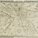
‘Sundial’ distorts view of the world
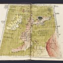
18 March 2017Highly unusual, not to say confusing, but mathematically correct is the view of the world as seen in this untitled map of 1640 that made £4500 in a Dominic Winter (19.5% buyer’s premium) sale of March 1.
$10m puts TEFAF – and New York – on the map
21 October 2016Among the undisputed highlights of TEFAF New York Fall is the most expensive map ever offered on the open market.
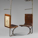
Eiffel Tower girder among lots up for auction at Drouot
24 September 2016Fancy owning a piece of the Eiffel Tower, the ceiling from a Parisian boulangerie or butcher’s shop or an old seat from the Metro?
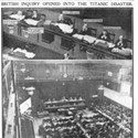
New Titanic record set at £220,000
06 June 2011A VERY large, hand-drawn plan of the Titanic, used in the official inquiry after it sank in 1912, has sold for £220,000 at Wiltshire auction house, Henry Aldridge & Son.
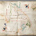
Manuscript map of North America takes £170,000
24 January 2011THIS exceptional 17th century map, depicting settlements in Canada and North America, was unearthed by Somerset auctioneers Lawrences in the attic of The House of Glennie, near Huntly, Aberdeenshire.
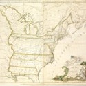
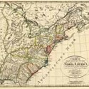
Record for a map as Buell’s America takes $1.8m
20 December 2010OFFERED this month at Christie's New York, a copy of Abel Buell's 1784 New and Correct Map of the United States of America... became the most expensive map ever sold at auction.
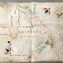
Attic find reveals an early guide to Hudson’s Bay
13 December 2010UNEARTHED in a Scottish attic, this exceptional 17th century map, depicting old fishing settlements in Canada and North America is expected to attract international interest when offered at auction in Somerset in January.
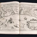
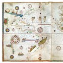
All at sea for the first time and earning a £52,000
18 December 2007A copy of the earliest printed sea atlas sold for a record £52,000 to a Dutch dealer in an Anderson & Garland sale of November 28.
Shapero bids record £1.9m for first printed atlas
16 October 2006When Sotheby’s sold the first portion of the Wardington library of atlases and geographies last year, London dealer Bernard Shapero set a cartographic auction record by paying £1.3m for the ‘Doria’ atlas, a superb collection of so-called Lafreri School maps of the latter part of the 16th century.
Dealer admits rare map crime spree
04 July 2006THE notorious map thief Edward Forbes Smiley III has appeared in court in the US where he admitted to stealing 97 antique maps worth more than $3m.
£1.3m atlas in pole position
25 October 2005BY IAN MCKAYWRITING about some of the more important items in his peerless private collection of atlases and geographies, the late Lord Wardington said of the Doria Atlas: “I just hope that it... will prove to be as good an investment in the future as I might have made in stocks and shares.”
The State that never was...
09 September 2004IN 1784, settlers in what is now North Carolina and eastern Tennessee put together a plan for a new state that was to be named in honour of Benjamin Franklin.
Too many tourists
01 September 2004HOW many dealers, I wonder, dread, rather than dream of, their business area being “discovered”? Long before Covent Garden became a trendy mecca for international tourists, one of the familiar attractions for habitués was London dealer Arthur Middleton’s distinctive shop in New Row, full of early globes and all sorts of antique scientific instruments.
Provenance and craftsmanship overcome risk of overexposure
10 August 2004AS its title suggests, the June 30 sale of scientific, medical and engineering works of art held by Christie’s South Kensington (19.5/12% buyer's premium) was something of a mixed bag. The 216-lot auction incorporated anything from 18th century microscopes and preserved amphibians to delft barbers’ bowls and scale models of locomotives.
On the streets, on the roads and on the run from press gangs...
13 May 2004THE opening map and atlas section of the Bonhams Bath sale of April 26 included a copy in rebacked contemporary calf of the first and only published volume of the 1675 first edition of John Ogilby’s Britannia with its general map and 100 engraved strip road maps, at £7000.
Lewis & Clark and that highly significant overland map...
27 August 2003Though no direct relationship has yet been established, there are very obvious similarities between the manuscript map reproduced right and one of the more significant maps in American history, the engraved map, right lower, found in the History of the Expedition under the Commands of Captains Lewis and Clark... in 1804-06.
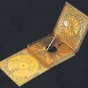
Coming up at Thomas Mawer & Sons.....
26 August 2003THE fascinating pocket sundial, right, dated to 1585 and attributed to the Elizabethan mapmaker Augustine Ryther (1550-93) is to be offered on September 25 at the Lincoln rooms of Thomas Mawer & Sons. Although Ryther was better known for his map engraving, he also created a number of high quality brass instruments, of which only two have so far been documented.
In a haven of tranquillity…
08 April 2003Topographical views of Valetta Harbour, Malta, continue to be one of the most solid performers in the salerooms. The latest quality example to turn up in the provinces was this signed Girolamo Gianni (1837-1887) oil on card, right, offered at the Chichester rooms of Stride’s (15% buyer’s premium) on February 28 with an estimate of £4000-6000.
Mapping & Moon Gazing
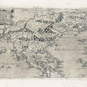
28 February 2003A Ptolemaic world map from the Nuremburg Chronicle was sold for £12,000 (£7500) as part of a December 12 sale of maps and prints held by Swann, while bid to $6000 (£3750) was the Map to illustrate Prince Maximilien of Wied’s Travels in the Interior of North America reproduced right.
Valuable stolen atlases were broken up and maps sold off
28 October 2002UK: A man who stole two extremely rare atlases to remove maps and sell them individually over the Internet has been jailed for 15 months.

- Adam Partridge
- Northern, Contemporary & Selected Art
- 20 Apr 2024 - 10:00 AM
- Mendip Auction Rooms
- Fashion, Textiles, Handbags & Interiors
- 23 Apr 2024 - 10:00 AM
- Warrington & Northwich
- Toys, Games & Transport
- 23 Apr 2024 - 10:00 AM
- Plakas Auctions
- Islamic & Indian Works of Art
- 23 Apr 2024 - 12:00 PM
- Thimbleby & Shorland
- Horse-Drawn Vehicles, Equestrian Pictures, Models & Books
- 24 Apr 2024 - 08:00 AM
- Auctioneum
- Antiques & 20th Century Silver
- 24 Apr 2024 - 08:55 AM

Categories
-
- Arms, Armour & Militaria
- Bank notes
- Books & Periodicals
- Cameras & Camera Equipment
- Classic Cars, Motorcycles & Automobilia
- Coins
- Collectables
- Entertainment Memorabilia
- Kitchenalia
- Maps
- Models, Toys, Dolls & Games
- Musical Instruments & Memorabilia
- Scientific Instruments
- Sporting Memorabilia & Equipment
- Stamps
- Taxidermy & Natural History
- Tools
- Wines & Spirits
- Writing Instruments
News
-
- Art finance
- Auctions
- Brexit
- Buyer's and seller's premiums
- Coronavirus
- Delivery and Shipping
- Education and Training
- Endangered Species
- Events and conferences
- Industry data
- Insurance
- Internet
- Law, crime and regulation
- Museum acquisitions
- Museum deaccessioning
- Obituaries
- Premises and Property
- Private Sales
- Recruitment
- Restoration
- TV shows
-
- 1818 Auctioneers
- Adam Partridge
- Adam's
- Addisons
- Ader
- Aguttes
- Alastair Gibson Auctions
- Alcala Subastas
- Aldridges
- Amersham Auction Rooms
- Anderson & Garland
- Andrew Smith & Son
- Anthemion
- AntikBar
- Antony Cribb
- Artcurial
- Arthur Johnson & Sons
- Aston's
- Auction Team Breker
- Auctionata
- Auctioneum
- Babuino
- Bainbridge Adam Partridge
- Baldwin's
- Bamfords
- Barbara Kirk
- Barbers
- Batemans
- BBR Auctions
- Bearnes Hampton & Littlewood
- Beaussant Lefèvre
- Bellmans
- Bentley’s
- Biddle & Webb
- Bigwood
- Bishop & Miller
- Bleasdales
- Bloomsbury Auctions
- Boldon Auction Galleries
- Bonhams
- Bonhams Skinner
- Bosleys
- Bourne End Auction Rooms
- Brettells
- Brighton General Auctions
- Brightwells
- Bristol Auction Rooms
- Brown & Co
- Bruun Rasmussen
- Burstow & Hewett
- Byrnes
- C&T
- Cambi Casa d'Aste
- Canterbury Auction Galleries
- Capes Dunn
- Catherine Southon
- Cato Crane
- Chalkwell
- Charles Miller
- Charles Ross Auctioneers
- Charterhouse
- Cheffins
- Chilcotts
- Chippenham Auction Rooms
- Chiswick Auctions
- Chorley's
- Christie's
- Clark & Simpson
- Clars Auction Gallery
- Clevedon Salerooms
- Comic Book Auctions
- Cotswold Auction Company
- Cottees
- Cowans
- Criterion
- Crow’s Auctions Gallery
- Curated Auctions
- Cuttlestones
- Czerny
- David Duggleby
- Dawsons
- Denhams
- Dominic Winter
- Dore & Rees
- Dorotheum
- Doyle New York
- Dreweatts
- Duke's
- Durrants
- Eastbourne Auctions
- Eldreds
- Elmwood’s
- Elstob Auctioneers
- Ewbank's
- Featonby's
- Fellows
- Fieldings
- Fine Art Auction Group
- Fine Art Bourse
- Flints Auctioneers
- Fonsie Mealy
- Forum Auctions
- Frank Marshall
- Freeman's
- Freeman's Hindman
- Gardiner Houlgate
- Gary Don
- George Kidner
- Gerrards Auction Rooms
- Gildings
- Golding Young & Mawer
- Gorringes
- Graham Budd
- Grand Auctions
- Great Western Auctions
- Greenslade Taylor Hunt
- Gros & Delettrez
- H&H Classics
- Halls Fine Art
- Hampstead Auctions
- Hannam’s
- Hansons
- Harper Field
- Hartleys
- Henry Adams
- Henry Aldridge & Son
- Heritage Auctions
- Hermann Historica
- High Road Auctions
- Hindman
- Holloways
- Holt's
- Hôtel Drouot
- Hotlotz
- Humbert & Ellis
- Hutchinson Scott
- Jacobs & Hunt
- John Nicholson
- John Pye Auctions
- Jones & Jacob
- JS Fine Art
- Jubilee Auction Rooms
- Juliens
- Kerry Taylor
- KettererKunst
- Keys
- Kidson-Trigg
- Kinghams
- Kings Russell
- Knights Auctions
- Knowle Auction Rooms
- Koller
- Lacy Scott & Knight
- Laidlaw
- Lawrences of Bletchingley
- Lawrences of Crewkerne
- Lay’s Auctioneers
- Lempertz
- Leonard Joel
- Lindsay Burns
- Littleton
- Lockdales
- Locke & England
- London Auctions
- Lots Road Auctions
- Louis Taylor
- Lyon & Turnbull
- MacDougall's
- Mallams
- Mander
- Marlows of Stafford
- Martel Maides
- Maxwells
- McTear's
- Mellors & Kirk
- Michael Bowman
- Millon
- Minster Auctions
- Mitchells
- Moore Allen & Innocent
- Morphets
- Morton & Eden
- Mossgreen
- Mulberry Bank Auctions
- Mullock's
- Nagel
- Nesbits
- Netherhampton Salerooms
- Nicholas Mellors
- Nigel Ward
- Noble Investments
- Noonans
- Olympia Auctions
- Omega Auctions
- Onslows
- Osenat
- Paddle8
- Parker Fine Art Auctions
- Paul Beighton Saleroom
- PBA Galleries
- Peter Francis
- Philip Serrell
- Phillips
- Piasa
- Pierre Bergé & Associes
- Piers Motley
- Plymouth Auction Rooms
- Potter & Potter
- Potteries Auctions
- Rago Auctions
- Railtons
- Ramsay Cornish
- Reeman Dansie
- Rendells
- Richard Edmonds Auctions
- Richard Winterton
- Ritchies
- RM Sotheby’s
- Rogers Jones
- Roma Numismatics
- Roseberys
- Ross’s of Belfast
- Rowley's
- Rushbrooks
- Ryedale
- Semley
- Sheffield Auction Gallery
- Sheppard’s
- Silverwoods
- Sloane Street Auctions
- Sotheby's
- Sovereign Rarities
- Special Auction Services
- Spicers
- Spink
- St Jamess Auctions
- Staceys
- Stanley Gibbons Group
- Sterling Vault Auctioneers
- StockholmsAuktionsverk
- Stride & Son
- Summers Place Auctions
- Swan Fine Art Auctioneers
- Swann
- Sworders
- Tajan
- Tamlyns
- Tayler and Fletcher
- Taylor's Auctions
- Tennants
- The Pedestal
- Thimbleby & Shorland
- Thomas Del Mar
- Thomas N Miller
- Thomas R Callan
- Thomas Watson
- Thomaston Place
- Thomson Roddick & Medcalf
- Thomson Roddick Scottish Auctions
- Timeline
- Toovey's
- Trevanion
- Truro Auction Centre
- TW Gaze
- Unique Auctions
- Vectis
- Veritas
- W&H Peacock
- Wallis and Wallis
- Warren & Wignall
- Watches of Knightsbridge
- Wellers
- Wessex Auction Rooms
- Whitton & Laing
- Whittons
- Whytes
- Wilkes & Curtis
- Wilkinson's Auctioneers
- William George & Co
- Wilson55
- Woolley & Wallis
- Wotton Auction Rooms
- Wright Marshall
-
- 1stdibs
- Advertising Standards Authority
- Antiquarian Booksellers Association
- Antique Young Guns
- Antiquities Dealers’ Association
- Art Business Conference
- Art Fund
- Art Loss Register
- Art Recovery International
- Art UK
- Arts Council England
- Assay Office
- Auction Technology Group
- BADA
- BAMF
- CADA
- CINOA
- Company of Arts Scholars
- DACS
- DEFRA
- DMG
- EBay
- Hiscox
- LAPADA
- Lot-tissimo
- National Trust
- NAVA
- Provincial Booksellers Fairs Association
- RICS
- Society of London Art Dealers
- SOFAA
- the saleroom
- Triple-A Auctioneers
-
- Adams Antiques Fairs
- Affordable Art Fair
- Alexandra Palace fair
- Antiques Centres
- Antiques Dealers Fair Limited
- Ardingly Fair
- Armchair Art Fair
- Art & Antiques for Everyone Fair
- Art Antiques London
- Art, Antiques & Interiors Expo
- Arthur Swallow Fairs
- Bath Decorative Antiques Fair
- Battersea Decorative Fair
- Bermondsey Market
- Book Fairs
- BRAFA
- British Art Fair
- Brussels Fairs
- CADA Fair
- Car Boot Fairs
- Clarion Events
- Continuity Fairs
- Cooper Events
- Ephemera fairs
- Fine Art Asia
- Fine Arts Paris
- Firsts
- Florida Fairs
- French Fairs
- Frieze
- Frieze Masters
- Galloway Antiques Fairs
- Harrogate Fairs
- Hatton Garden
- Haughton Fairs
- Hong Kong Fairs
- IACF
- Jaguar Fairs
- LAPADA Fair
- Lincolnshire Antiques and Home Show
- London Original Print Fair
- Masterpiece
- Miami Fairs
- Midcentury Modern
- Modern British Art Fair
- NEC Birmingham
- New York Fairs
- Newark Fair
- Newbury Antiques and Collectors Fair
- Olympia Fair
- PAD London
- Palm Beach Fairs
- Paris Biennale
- Paris Fairs
- Paris Parcours
- Paris Tableau
- Penman Fairs
- Philadelphia Fairs
- Photography fairs
- Regional Fairs
- Salon du Dessin
- Sandown Park Racecourse Fair
- Showground Fairs
- Swinderby Fair
- TEFAF
- The Open Art Fair
- The Treasure House Fair
- Winter Antiques Show
- Works on Paper Fair
-
- Alfred Taubman
- Bendor Grosvenor
- Bill Ruprecht
- Charles Hanson
- Charlie Ross
- Cornelius Gurlitt
- David Lester
- Ed Dolman
- Eric Knowles
- François Pinault
- Ingrid Nilson
- Lennox Cato
- Lord Ashcroft
- Marco Forgione
- Mark Law
- Sheikh Saud Bin Mohammed Al-Thani
- Simon de Pury
- Sue Ede
- Tad Smith
- Tim Goodman
- Victoria Borwick
-
- Abbott and Holder
- Agnews
- Alastair Dickenson
- Andrew Sim
- Blairman
- Carter Marsh
- Colnaghi
- Daniel Katz
- Dickinson
- Fabrizio Moretti
- Ian Towning
- Johnny Van Haeften
- London Silver Vaults
- Mallett
- Mark Weiss
- Partridge Fine Art
- Petworth Antiques Dealers
- Philip Mould
- Pimlico Road Dealers
- Richard Green
- Robert Young
- Roger Keverne
- Rupert Maas
- SJ Phillips
- Wartski
-
- A Lawyer Writes
- Around the Auction Houses
- Art Market
- Auction Reports
- Bid Barometer
- Books and Works on Paper
- Dealers' Diary
- Fairs, Markets, Shops and Centres
- Features
- Front Page and News
- International (print edition)
- Interviews
- Letters to the Editor
- News in Brief
- Obituaries (print edition)
- Opinion
- Pick of the Week
- Precious Metals Prices
- Previews
- Soapbox
- Special Reports
- Then & Now