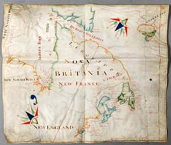
The manuscript map, meticulously coloured and remarkably well preserved on a 2ft 1in x 2ft 7in (68 x 80cm) sheet of vellum, depicts North West America and Canada from Hudson's Straights [sic] south through Labrador and Newfoundland to New England and New York.
Dated 1699, it is signed by the London "plattmaker" (cartographer) John Thornton (1641-1708), a prolific member of the Thames School of map and chart makers, who worked as a hydrographer for both the English East India Company and the Hudson's Bay Company.
The map's surprising appearance in Scotland is explained by the business interests of the late vendor's father: Harold Fortington had links with Canada and North America before the Second World War.
Expected to realise £50,000-80,000 when offered for sale in Crewkerne on January 17, it attracted three keen telephone bidders and three bidders in the room before it sold to Oxford-based map specialist Daniel Crouch Rare Books at £170,000 (plus 19.5% buyer's premium). Conscious that no similar map had been on the market for 50 years (the British Library own an earlier Thornton map of Hudson's Bay, dated 1685), he was buying for stock.
Daniel Crouch, who was aided in his research by Maureen Dolyniuk at the Hudson Bay Company (HBC) archives, told ATG: "John Thornton was the main supplier of maps to the Hudson's Bay Company in the latter part of the 17th and early 18th century, drafting ten or 11 maps and charts to the company between 1680 and 1702."
Committee minutes for 1700 record that the Company paid Thornton £3 for the delivery of two "mapps of Hudson's Bay" that were used to illustrate its claims and assert its rights over its domain in North America at a time when the French were disputing the company's proprietorship of all the shores and immediate territory of Hudson and James Bays.
A feature of this 1699 map is a boundary line in vibrant red running from the Hudson-James Bay watershed through Lake Mistassini, north east to the Labrador coast just below 60 degrees north latitude. At the time the French were insisting on a boundary extending across James Bay at 52 degrees north, with their ownership confirmed to the south of this line.
No John Thornton map now survives in the HBC archives, but they do hold two similar maps of Hudson's Bay produced in 1709 by his son, Samuel Thornton, who took over his father's map-making business.
John Thornton's map of 1699 appears again to have been the template for these charts that were used during the negotiations that led to the Treaty of Utrecht in 1713 and, more recently, during the 1927 Labrador boundary dispute between Canada and Newfoundland which established the border between Quebec and Labrador.
By Roland Arkell