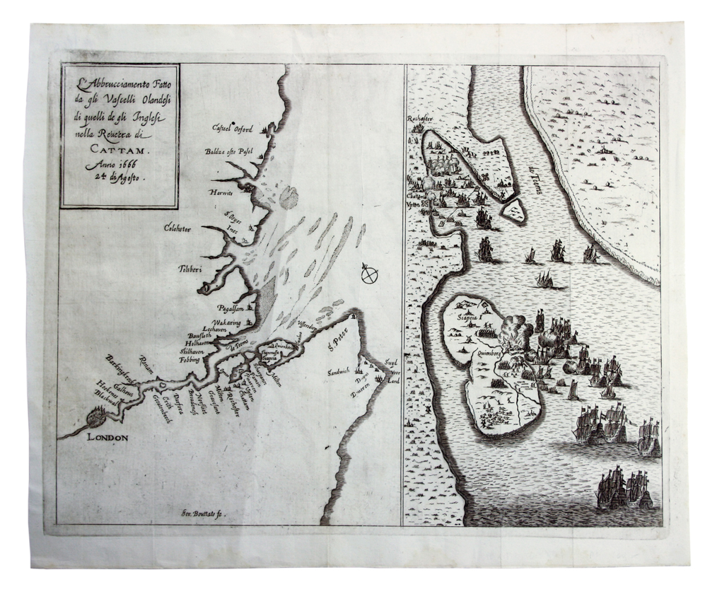
Dealer Tim Bryars will display the two-part map which shows the raid on the Medway – a notorious military defeat for the English in June 1667 that brought about the end of the Second Anglo-Dutch War.
On the left side of the engraving is a map of London, the Thames Estuary, north Kent and south Essex coasts. The right side depicts the Dutch ships invading the Medway in Kent and bombarding the Isle of Sheppey as the bitterly fought conflict over control of the seas and trade routes reached its conclusion.
“The Dutch occupied the Isle of Sheppey for several days, and burned anything which was not worth looting,” said Bryars. “The Dutch fleet sailed further up the Thames to Gravesend, and up the Medway as far as Chatham, burning or capturing many of the Royal Navy’s most powerful vessels, including the flagship Royal Charles.”
Rarity
Following the Raid on the Medway, a number of engravings were made with the Dutch keen to publicise their victory. Mapmakers such as Michiel Comans and Nicolas Visscher produced some notable examples, but Bryars’ 13 x 17in (33.5 x 43.5cm) copper engraving is probably lesser known.
It was produced by the Flemish engraver Gaspar Bouttats, who was active in Antwerp in the mid-17th century. Known primarily for portraits and topographical prints, rather than cartography, a few examples of his engravings can be found in the National Portrait Gallery and the British Library.
“This map is highly scarce,” Bryars told ATG. “I’ve only been able to find one other institutional example which is in the British Library.”

London book and map dealer Tim Bryars.
Bryars described the work as a “pan-European curiosity” given that it is a Flemish engraver’s depiction of an English-Dutch conflict which was probably printed in Vienna and carries a legend in Italian: L'abbrucciamento fatto dagli, vascelli Olandesi di quelli de gli Inglesi nella réuéera di Cattam anno 1666 24 di agosto, which translates into English as ‘The tussle by Dutch ships against those of the English in the Chatham reef’. The map carries the wrong date for the battle, listing it as 24 August 1666 rather than June 10-12.
Bryars described the map as in “good clean condition” and has given it a £500 price-tag at the fair.
Battle Plan
The raid on the Medway came after the English victory to control the Channel almost a year before known as the St James Day Battle, and a devastating raid on Dutch shipping – Holmes’s Bonfire – on August 10-20, 1666.
However, with Charles II’s side fleet laid up in The Medway with skeleton crews following the Great Plague and the Fire of London, the mouth of the Thames was poorly defended during the year that followed, allowing the Dutch to plan a tactical advance and launch the raid on the Medway on June 10, 1667.
Late that day, the British stretched an iron chain across the river at Gillingham to block the raiders’ progress, but the Dutch were able to break through it on June 12 before going on to destroy or capture shipping, using a terrifying fleet of fire ships.
The following day the Dutch made their way up the Medway, burning and capturing more ships, while forcing others to run aground to avoid destruction.
The Dutch then turned tail and sailed to the mouth of the Thames, blockading London and only retreating just over two weeks later when hoped for support from the French did not arrive and it had become clear that the British had reinforced their defences.
Bryars noted that the emergence of the Bouttats map comes almost 350 years to the day since the event.
The London Map Fair takes place at the Royal Geographical Society on June 17-18 with over 40 dealers from the UK, Europe and US offering maps priced from £100 to £100,000.
A preview of the London Map Fair will appear in the Dealers’ Diary section of ATG’s print edition (Issue 2294).