Maps
The value of an antique map is usually determined by the geographical area covered, historical importance, quality of production, size, decorative appeal and rarity.
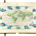
Maps made during the Golden Age of Exploration (spanning the early 15th to early 17th centuries) are of particular interest to collectors with examples by the 17th century Dutch cartographers Willem Blaeu and his son Joan among the most highly prized.
As well as maps, this category also includes antique atlases, globes, cartographic reference books, travel books, charts and plans.
Upcoming books, maps and prints highlights for summer 2021
10 May 2021A selection of upcoming books, maps and prints at auctions around the UK and overseas.

Brexit case study: ‘The hassle factor is enormous’ – Daniel Crouch Rare Books
01 March 2021One of the pleasures of Daniel Crouch’s work life has been buying trips to the Continent – for the serendipity of making contacts as well as the chance to handle the goods.
Newton celestial globe stolen after smash and grab raid in Fulham
03 February 2021The antiques trade has suffered another smash and grab theft following a wave of robberies targeting map dealers in central London before Christmas.
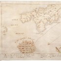
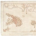
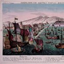
Saved for the nation: Armada maps are bought with help from Antiques Trade Gazette
01 February 2021Armada maps stay in UK after ATG story inspires campaign
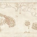
Armada maps saved for the nation after Navy museum secures funding from grants and the public
28 January 2021A group of hand-drawn Armada maps depicting a key moment in England’s history have been saved after a fundraising campaign by the Royal Navy museum.
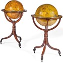
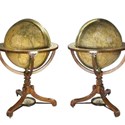
Georgian globes travel to Los Angeles
09 November 2020This pair of early 19th century George III period terrestrial and celestial globes in mahogany stands are by Dudley Adams, (1762-1830) a member of the well-known Adams family of globemakers.
Public cash call to help keep Armada maps in the UK
03 November 2020The National Museum of the Royal Navy hopes to raise £600,000 to stop the export of a group of hand-drawn Armada maps to an overseas buyer.
Copy of ‘the earliest obtainable map printed in Arabic’ reaches 15-times estimate at Forum Auctions
19 October 2020The atlas 'Ay majmu’ kharitat rasm al-ard…,' published by the Church Missionary Society Press in Valetta, is today considered the earliest obtainable atlas printed in Arabic.
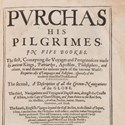
Early English sea atlas among real sales at ‘virtual’ book fair
21 September 2020An English translation of a Dutch 16th century sea atlas was among the standout sales at the recent online edition of Firsts: London’s Rare Book Fair.

5 Questions: map dealer Massimo De Martini
10 August 2020Massimo De Martini started trading as Altea Maps in 1992 and now runs the business from his Mayfair premises. He is also co-organiser of the London Map Fair.
Overseas buyer for Armada maps unless £600,000 is found
20 July 2020A public campaign to keep rare maps of the Spanish Armada in the country will be needed to raise the required £600,000.
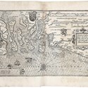
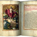
Books unite the trade
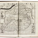
20 July 2020This portolan atlas known as the Harisse Codex is attributed to cartographer Battista Agnese, who worked in Venice.
"Invaluable archive" of London Underground posters and drawings sells 17-times above estimate in Berkshire
20 July 2020London Underground maps come up relatively regularly at auction – and typically it is the various 1930s states of the classic Harry Beck design that command the really high prices.
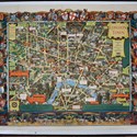
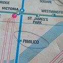
London updated with a fifties festival
20 July 2020The first version of this map of London was issued by the Southern Railway in 1938. It was designed by Kerry Lee (1902-88) who brought it up to date for British Railways in the 1950s.
Rare Spanish Armada maps blocked from export in the hope a UK buyer can pay £600,000 to save them for the nation
13 July 2020A group of 10 drawings that depict the Elizabethan naval battle have been temporarily prevented from being exported in the hope an institutional buyer can raise funds to keep them in the UK.
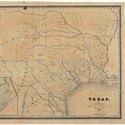
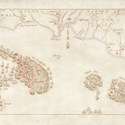
Texas located for the third time
13 July 2020Rare early map of the region from three years before the Alamo has another saleroom outing
British voyages and a letter from Churchill star at Sotheby's
22 June 2020The two most expensive lots in an online London books sale of just 100 lots could hardly have been more different.
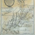
Galleries go Down Town for selection of New York views
08 June 2020A sizeable collection of 18th and 19th century New York views, maps and maritime prints belonging to the Down Town Association, an historic private club located in Manhattan’s financial district, was the focus of a sale held by Arader Galleries (20% buyer’s premium).
Dealers Online: 23 books, maps and works on paper available from dealers' websites
01 June 2020Our selection of books, maps and works on paper available to view and buy from dealers online.
Dealers Online: ATG's selection of 39 books, maps and works on paper available from dealers' websites
26 May 2020The annual 'Rare Books London' schedule of events is cancelled this year due to COVID-19, but plenty of book dealers are still doing business.

- Adam Partridge
- Studio Ceramics
- 19 Jul 2024 - 10:00 AM
- Adam Partridge London
- Antiques & Fine Art
- 23 Jul 2024 - 10:00 AM
- McTear's
- Antiques & Interiors
- 25 Jul 2024 - 09:30 AM
- W&H Peacock
- Antique Furniture, Collectables, Toys, Jewellery & Watches
- 02 Aug 2024 - 09:30 AM
- Unique Auctions
- Antiques, Jewellery, Furniture & Collectables
- 03 Aug 2024 - 09:00 AM
- Adam Partridge Devon
- Fine Art, Antiques & Collectables
- 05 Aug 2024 - 10:00 AM

Categories
-
- Arms, Armour & Militaria
- Bank notes
- Books & Periodicals
- Cameras & Camera Equipment
- Classic Cars, Motorcycles & Automobilia
- Coins
- Collectables
- Entertainment Memorabilia
- Kitchenalia
- Maps
- Models, Toys, Dolls & Games
- Musical Instruments & Memorabilia
- Scientific Instruments
- Sporting Memorabilia & Equipment
- Stamps
- Taxidermy & Natural History
- Tools
- Wines & Spirits
- Writing Instruments
News
-
- Art finance
- Auctions
- Brexit
- Buyer's and seller's premiums
- Coronavirus
- Delivery and Shipping
- Education and Training
- Endangered Species
- Events and conferences
- Industry data
- Insurance
- Internet
- Law, crime and regulation
- Museum acquisitions
- Museum deaccessioning
- Obituaries
- Premises and Property
- Private Sales
- Recruitment
- Restoration
- TV shows
-
- 1818 Auctioneers
- Adam Partridge
- Adam's
- Addisons
- Ader
- Aguttes
- Alastair Gibson Auctions
- Alcala Subastas
- Aldridges
- Amersham Auction Rooms
- Anderson & Garland
- Andrew Smith & Son
- Anthemion
- AntikBar
- Antony Cribb
- Artcurial
- Arthur Johnson & Sons
- Aston's
- Auction Team Breker
- Auctionata
- Auctioneum
- Babuino
- Bainbridge Adam Partridge
- Baldwin's
- Bamfords
- Barbara Kirk
- Barbers
- Batemans
- BBR Auctions
- Bearnes Hampton & Littlewood
- Beaussant Lefèvre
- Bellmans
- Bentley’s
- Biddle & Webb
- Bigwood
- Bishop & Miller
- Bleasdales
- Bloomsbury Auctions
- Boldon Auction Galleries
- Bonhams
- Bonhams Skinner
- Bosleys
- Bourne End Auction Rooms
- Brettells
- Brighton General Auctions
- Brightwells
- Bristol Auction Rooms
- Brown & Co
- Bruun Rasmussen
- Burstow & Hewett
- Byrnes
- C&T
- Cambi Casa d'Aste
- Canterbury Auction Galleries
- Capes Dunn
- Catherine Southon
- Cato Crane
- Chalkwell
- Charles Miller
- Charles Ross Auctioneers
- Charterhouse
- Cheffins
- Chilcotts
- Chippenham Auction Rooms
- Chiswick Auctions
- Chorley's
- Christie's
- Clark & Simpson
- Clars Auction Gallery
- Clevedon Salerooms
- Comic Book Auctions
- Cotswold Auction Company
- Cottees
- Cowans
- Criterion
- Crow’s Auctions Gallery
- Curated Auctions
- Cuttlestones
- Czerny
- David Duggleby
- Dawsons
- Denhams
- Dominic Winter
- Dore & Rees
- Dorotheum
- Doyle New York
- Dreweatts
- Duke's
- Durrants
- Eastbourne Auctions
- Eldreds
- Elmwood’s
- Elstob Auctioneers
- Ewbank's
- Featonby's
- Fellows
- Fieldings
- Fine Art Auction Group
- Fine Art Bourse
- Flints Auctioneers
- Fonsie Mealy
- Forum Auctions
- Frank Marshall
- Freeman's
- Freeman's Hindman
- Gardiner Houlgate
- Gary Don
- George Kidner
- Gerrards Auction Rooms
- Gildings
- Golding Young & Mawer
- Gorringes
- Graham Budd
- Grand Auctions
- Great Western Auctions
- Greenslade Taylor Hunt
- Gros & Delettrez
- H&H Classics
- Halls Fine Art
- Hampstead Auctions
- Hannam’s
- Hansons
- Harper Field
- Hartleys
- Henry Adams
- Henry Aldridge & Son
- Heritage Auctions
- Hermann Historica
- High Road Auctions
- Hindman
- Holloways
- Holt's
- Hôtel Drouot
- Hotlotz
- Humbert & Ellis
- Hutchinson Scott
- Jacobs & Hunt
- John Nicholson
- John Pye Auctions
- Jones & Jacob
- JS Fine Art
- Jubilee Auction Rooms
- Juliens
- Kerry Taylor
- KettererKunst
- Keys
- Kidson-Trigg
- Kinghams
- Kings Russell
- Knights Auctions
- Knowle Auction Rooms
- Koller
- Lacy Scott & Knight
- Laidlaw
- Lawrences of Bletchingley
- Lawrences of Crewkerne
- Lay’s Auctioneers
- Lempertz
- Leonard Joel
- Lindsay Burns
- Littleton
- Lockdales
- Locke & England
- London Auctions
- Lots Road Auctions
- Louis Taylor
- Lyon & Turnbull
- MacDougall's
- Mallams
- Mander
- Marlows of Stafford
- Martel Maides
- Maxwells
- McTear's
- Mellors & Kirk
- Michael Bowman
- Millon
- Minster Auctions
- Mitchells
- Moore Allen & Innocent
- Morphets
- Morton & Eden
- Mossgreen
- Mulberry Bank Auctions
- Mullock Jones
- Nagel
- Nesbits
- Netherhampton Salerooms
- Nicholas Mellors
- Nigel Ward
- Noble Investments
- Noonans
- Olympia Auctions
- Omega Auctions
- Onslows
- Osenat
- Paddle8
- Parker Fine Art Auctions
- Paul Beighton Saleroom
- PBA Galleries
- Peter Francis
- Philip Serrell
- Phillips
- Piasa
- Pierre Bergé & Associes
- Piers Motley
- Plymouth Auction Rooms
- Potter & Potter
- Potteries Auctions
- Rago Auctions
- Railtons
- Ramsay Cornish
- Reeman Dansie
- Rendells
- Richard Edmonds Auctions
- Richard Winterton
- Ritchies
- RM Sotheby’s
- Rogers Jones
- Roma Numismatics
- Roseberys
- Ross’s of Belfast
- Rowley's
- Rushbrooks
- Ryedale
- Semley
- Sheffield Auction Gallery
- Sheppard’s
- Silverwoods
- Sloane Street Auctions
- Sotheby's
- Sovereign Rarities
- Special Auction Services
- Spicers
- Spink
- St Jamess Auctions
- Staceys
- Stanley Gibbons Group
- Sterling Vault Auctioneers
- StockholmsAuktionsverk
- Stride & Son
- Summers Place Auctions
- Swan Fine Art Auctioneers
- Swann
- Sworders
- Tajan
- Tamlyns
- Tayler and Fletcher
- Taylor's Auctions
- Tennants
- The Pedestal
- Thimbleby & Shorland
- Thomas Del Mar
- Thomas N Miller
- Thomas R Callan
- Thomas Watson
- Thomaston Place
- Thomson Roddick & Medcalf
- Thomson Roddick Scottish Auctions
- Timeline
- Toovey's
- Trevanion
- Truro Auction Centre
- TW Gaze
- Unique Auctions
- Vectis
- Veritas
- W&H Peacock
- Wallis and Wallis
- Warren & Wignall
- Watches of Knightsbridge
- Wellers
- Wessex Auction Rooms
- Whitton & Laing
- Whittons
- Whytes
- Wilkes & Curtis
- Wilkinson's Auctioneers
- William George & Co
- Wilson55
- Woolley & Wallis
- Wotton Auction Rooms
- Wright Marshall
-
- 1stdibs
- Advertising Standards Authority
- Antiquarian Booksellers Association
- Antique Young Guns
- Antiquities Dealers’ Association
- Art Business Conference
- Art Fund
- Art Loss Register
- Art Recovery International
- Art UK
- Arts Council England
- Assay Office
- Auction Technology Group
- BADA
- BAMF
- CADA
- CINOA
- Company of Arts Scholars
- DACS
- DEFRA
- DMG
- EBay
- Hiscox
- LAPADA
- Lot-tissimo
- National Trust
- NAVA
- Provincial Booksellers Fairs Association
- RICS
- Society of London Art Dealers
- SOFAA
- the saleroom
- Triple-A Auctioneers
-
- Adams Antiques Fairs
- Affordable Art Fair
- Alexandra Palace fair
- Antiques Centres
- Antiques Dealers Fair Limited
- Ardingly Fair
- Armchair Art Fair
- Art & Antiques for Everyone Fair
- Art Antiques London
- Art, Antiques & Interiors Expo
- Arthur Swallow Fairs
- Bath Decorative Antiques Fair
- Battersea Decorative Fair
- Bermondsey Market
- Book Fairs
- BRAFA
- British Art Fair
- Brussels Fairs
- CADA Fair
- Car Boot Fairs
- Clarion Events
- Continuity Fairs
- Cooper Events
- Ephemera fairs
- Fine Art Asia
- Fine Arts Paris
- Firsts
- Florida Fairs
- French Fairs
- Frieze
- Frieze Masters
- Galloway Antiques Fairs
- Harrogate Fairs
- Hatton Garden
- Haughton Fairs
- Hong Kong Fairs
- IACF
- Jaguar Fairs
- LAPADA Fair
- Lincolnshire Antiques and Home Show
- London Original Print Fair
- Masterpiece
- Miami Fairs
- Midcentury Modern
- Modern British Art Fair
- NEC Birmingham
- New York Fairs
- Newark Fair
- Newbury Antiques and Collectors Fair
- Olympia Fair
- PAD London
- Palm Beach Fairs
- Paris Biennale
- Paris Fairs
- Paris Parcours
- Paris Tableau
- Penman Fairs
- Philadelphia Fairs
- Photography fairs
- Regional Fairs
- Salon du Dessin
- Sandown Park Racecourse Fair
- Showground Fairs
- Swinderby Fair
- TEFAF
- The Open Art Fair
- The Treasure House Fair
- Winter Antiques Show
- Works on Paper Fair
-
- Alfred Taubman
- Bendor Grosvenor
- Bill Ruprecht
- Charles Hanson
- Charlie Ross
- Cornelius Gurlitt
- David Lester
- Ed Dolman
- Eric Knowles
- François Pinault
- Ingrid Nilson
- Lennox Cato
- Lord Ashcroft
- Marco Forgione
- Mark Law
- Sheikh Saud Bin Mohammed Al-Thani
- Simon de Pury
- Sue Ede
- Tad Smith
- Tim Goodman
- Victoria Borwick
-
- Abbott and Holder
- Agnews
- Alastair Dickenson
- Andrew Sim
- Blairman
- Carter Marsh
- Colnaghi
- Daniel Katz
- Dickinson
- Fabrizio Moretti
- Ian Towning
- Johnny Van Haeften
- London Silver Vaults
- Mallett
- Mark Weiss
- Partridge Fine Art
- Petworth Antiques Dealers
- Philip Mould
- Pimlico Road Dealers
- Richard Green
- Robert Young
- Roger Keverne
- Rupert Maas
- SJ Phillips
- Wartski
-
- A Lawyer Writes
- Around the Auction Houses
- Art Market
- Auction Reports
- Bid Barometer
- Books and Works on Paper
- Dealers' Diary
- Fairs, Markets, Shops and Centres
- Features
- Front Page and News
- International (print edition)
- Interviews
- Letters to the Editor
- News in Brief
- Obituaries (print edition)
- Opinion
- Pick of the Week
- Precious Metals Prices
- Previews
- Soapbox
- Special Reports
- Then & Now